Invention
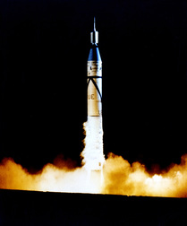 Explorer 1 launches from Cape Canaveral¹⁴
On October 4, 1957, the Soviet Union launched the first artificial satellite, Sputnik¹. Carried by an intercontinental ballistic missile, Sputnik was the first man-made object to be placed into orbit¹. Not to be outdone, the U.S. launched Explorer 1, their first satellite on January 31, 1958². The satellite was built by the Jet Propulsion Lab, who completed it in less than three months². Carried to orbit using a Jupiter C rocket, Explorer 1 was the first satellite with scientific instruments². The primary instrument was a cosmic ray detector that measured the radiation environment in Earth's atmosphere². However, this instrument was most likely damaged due to it being saturated by radiation from charged particles in Earth's magnetic field, and recorded levels much lower than expected². While it's final transmission was on May 23, 1958, Explorer 1 burned up in Earth's atmosphere on May 31,1970².
Long before the actual invention of satellites, they were considered for communications purposes. Arthurs C. Clarke from Britain wrote an article in 1945 describing the possibility of manned satellites in orbit to broadcast television programs³. He repeated the idea in another work in 1951/1952³. In a 1954 speech and a 1955 articles, John R. Pierce explained the idea of how satellite communications could function (using "mirrors" and "repeaters") and the potential profit³.
Long before the actual invention of satellites, they were considered for communications purposes. Arthurs C. Clarke from Britain wrote an article in 1945 describing the possibility of manned satellites in orbit to broadcast television programs³. He repeated the idea in another work in 1951/1952³. In a 1954 speech and a 1955 articles, John R. Pierce explained the idea of how satellite communications could function (using "mirrors" and "repeaters") and the potential profit³.
Development
There were many problems with the idea of using intercontinental ballistic missiles to launch satellites. They were designed to carry an object to the earth's surface, not place something into orbit³. In response, the DELTA Launch Vehicle was created in 1960³. The DELTA was designed to utilize a velocity change to make the orbit circular³. However, the DELTA was fairly small and unable to carry heavy satellites³. In order to launch heavier items, the ATLAS-CENTAUR and ARIANE (a European launch-vehicle) were used³. Since then, the Russian PROTON and the Chinese LONG MARCH have entered the market³. After 1963, geosynchronous (or "stationary" since they orbit around the Earth at the same speed as it rotates so they stay over one area) satellites became available³. These would spin in order to be stabilized³. In the mid-1970s, several satellites were built using three-axis stabilization so they did not need to spin like the earlier geosynchronous satellites³. Currently, three-axis stabilization is used the most often³.
Reconnaissance using satellites began in 1958 when Eisenhower formally endorsed the CORONA Program in February⁷. The CORONA Program was an attempt to use satellites to spy on Soviet missile launch sites and production facilities⁷. There were thirteen failed mission attempts before the first successful recovery of film from space on August 18, 1960⁷. The film recovered contained more overhead photographic coverage than all of the U-2 flights over the USSR to that date⁷. CORONA continued to gather intelligence on the USSR⁷. In February 1995, the project was finally declassified and shared with the public⁷.
The idea of satellite communications took off after Sputnik 1. NASA began experiments with "mirrors" or "passive" communication satellites with the ECHO program³. The Department of Defense looked into "repeater" or "active" satellites which amplify the received signal³. AT&T filed with the Federal Communications Commission in 1960 for permission to launch experimental communications satellites. By the middle of 1961, AT&T was building a medium-orbit satellite (TELSTAR) that NASA would launch, RCA (Radio Corporation of America) had been awarded a contract to build a medium-orbit active communication satellite (RELAY), and NASA had given a contract to Hughes Aircraft Company to build a 24-hour satellite (SYNCOM)³. TELSTAR and RELAY were launched in 1962 (SYNCOM was launched in 1963)³. Also in 1962, the U.S. passed the Communications Satellite Act, which stated that the U.S., while cooperating with other countries, would create a commercial communication satellite system as soon as practical in order to improve global communication⁴. AT&T had already been coordinating with its European telephone cable counterparts to build stations on Earth for TELSTAR experimentation³. NASA expanded this to include RELAY and SYNCOM experimentation³. On August 20, 1964, agreements between multiple countries (including the U.S.) were signed to create the International Telecommunications Satellite Organization (INTELSAT), which eventually assumed ownership of the satellites and the responsibility for the management of the global system³. Communications Satellite Corporation (COMSAT) launched the first commercial communications satellite on April 6, 1965 from Cape Canaveral³. This satellite, EARLY BIRD, utilized a 24-hour geosynchronous (stationary) satellite from Hughes Aircraft Company³. By the end of 1965, EARLY BIRD had provided 150 telephone "half-circuits" and 80 hours of television service³. INTELSAT (who was working with COMSAT to create a global system) launched the INTELSAT II series, which was a slightly better and longer-lived version of EARLY BIRD³. The INTELSAT III series came shortly after and provided Indian Ocean coverage, completing the global network³. This coverage was completed days before half a billion people watched Apollo 11 landed on the moon on July 20, 1969³. Domestic communications began in 1972 when TELESAT CANADA launched the first domestic satellite, ANIK, to serve the Canadian area³. The U.S. launched WESTAR I on April 13, 1974, the first U.S. domestic communications satellite³. RCA's RCA SATCOM F-1, and AT&T and COMSAT's COMSTAR soon followed³. They were used for voice and data, but television became a major user³. By the end of 1976, there were 120 transponders available over the U.S., each able to provide 1500 telephone channels or one TV channel³. Soon, the amount of channels available to most Americans skyrocketed³. In February of 1976, COMSAT launched a new kind of satellite, MARISAT to provide mobile services to the U.S. Navy and other maritime customers³. In 1979, the UN sponsored the establishment of the International Maritime Satellite Organization (INMARSAT) to provide a similar function for these types of satellites as INTELSAT had been for other communications. INMARSAT then launched INMARSAT II F-1 and later, INMARSAT III³. More countries joined INTELSAT and quite a few began their own domestic satellite services. Since 1986, Pan American Satellite has competed with INTELSAT in the international market³.
The idea of weather satellites began with Vanguard II in 1959, which contained light-sensitive cells able to provide information on Earth's cloud cover⁵. However, the satellite tumbled in orbit and could not return any information⁵. Also in 1959, Explorer VI was launched and transmitted the first photographs of Earth's atmosphere from space⁵. In 1960, the U.S. launched their first satellite for weather purposes, TIROS 1⁵. It sent 22,000 photos before it failed six weeks later⁵. Later versions of TIROS allowed for direct, real-time pictures to transmit to stations around the world⁵. In 1970, ITQS-I was launched⁵. Along with the ability to automatically send pictures, it had the ability to store global images for later transmission⁵. Another series, called NOAA (named after the National Oceanic and Atmosphere Administration), also monitored weather⁵. Some of these were geosynchronous satellites and thus able to observe one area continuously, detecting severe storms, tornadoes, and cloud and frontal weather movements⁵. NIMBUS (1960s) and NOAA-9 (1980s-1990s) measured temperatures and water vapor over the globe⁵. Eventually, the GOES (Geostationary Operational Environmental Satellites) Program began with GOES-1, which was launched on October 16, 1975⁶.
Use Today
Satellites continue to be used extensively. Surveillance satellites are still in use by both the U.S. government and private companies, such as Google Earth⁸. Commercial satellite imagery can make out objects that are as small as twenty inches across⁸. Military satellites have resolution down to ten inches⁸. These images assist greatly in maintaining accurate intelligence on other nations and in search and rescue operations (such as the recent one for the plane that went missing off the Australian coast)⁸. Commercial satellite imagery is available to anyone through the internet.
While in it's early days, satellites provided more capacity than submarine telephone cables at a much cheaper price, newer fiber-optic cables can compete³. For more domestic services, cellular telephone systems have by far beaten out satellites, however long-distance requires either satellites or fiber-optic cable³. Currently, communications are the most common usage for satellites⁹. Companies such as DIRECTV and DISH offer satellite TV to their customers. INTELSAT privatized and became Intelsat, but still offers satellite communications for various customers¹⁶.
The GOES Program continues to provide weather monitoring using new technology and sensor (such as Doppler radar)⁶. They help meteorologists predict the weather, including thunderstorms, tornadoes, flash floods, snow squalls, and hurricanes⁶. They even help in recording dust storms, volcano eruptions, and the spread of forest fires⁶. The current GOES Program allows the satellites to recieve information from sensors (such as rain gauges, seismometers, tide gauges, buoys, and weather stations) on the surface when it requests or an emergency level is reached⁶.
Footnotes
- http://www.history.com/topics/space-race
- http://www.nasa.gov/mission_pages/explorer/explorer-overview.html
- http://history.nasa.gov/satcomhistory.html
- http://www.presageinc.com/contents/experience/satellitereform/contents/briefingbook/technology/1962act.pdf
- http://www.encyclopedia.com/topic/weather_satellite.aspx
- http://goes.gsfc.nasa.gov/text/history/goes/goes.html
- https://www.cia.gov/news-information/featured-story-archive/2010-featured-story-archive/corona-the-nation2019s-first-photoreconnaissance-satellite.html
- http://www.washingtonpost.com/blogs/the-switch/wp/2014/03/20/behind-the-spy-satellite-tech-that-led-mh370-investigators-to-australia/
- http://satellites.findthedata.com/
- http://www.satellite-tv.info/
- http://www.nytimes.com/2012/10/27/us/dying-satellites-could-lead-to-shaky-weather-forecasts.html?_r=0
- http://googleblog.blogspot.com/2012/01/google-earth-62-its-beautiful-world.html
- http://www.theregister.co.uk/2014/03/21/mh370_flight_satellite_photos/
- http://www.nasa.gov/multimedia/imagegallery/image_feature_1008.html
- https://www.cia.gov/news-information/featured-story-archive/2015-featured-story-archive/corona-declassified.html
- http://www.intelsat.com/
Title Image: http://innov8tiv.com/ethiopia-prepares-launch-satellite-space/
